Fortified Complex of Monte Baranta
One of the oldest fortifications in Sardinia, with powerful prehistoric walls from the Copper Age.

Fortified Complex of Monte Baranta
Fortified Complex of Monte Baranta
Contact
- Comune di Olmedo (SS)
- +390799019000
- +3907990119004
- Website
Access information
From Olmedo, follow the SP19 road towards Alghero for about 1.2 km, then turn left, following the tourist signs, onto a dirt road and travel for 850 m. Upon reaching the parking area, a pedestrian path about 700 m long will lead to the plateau where the archaeological complex is located.
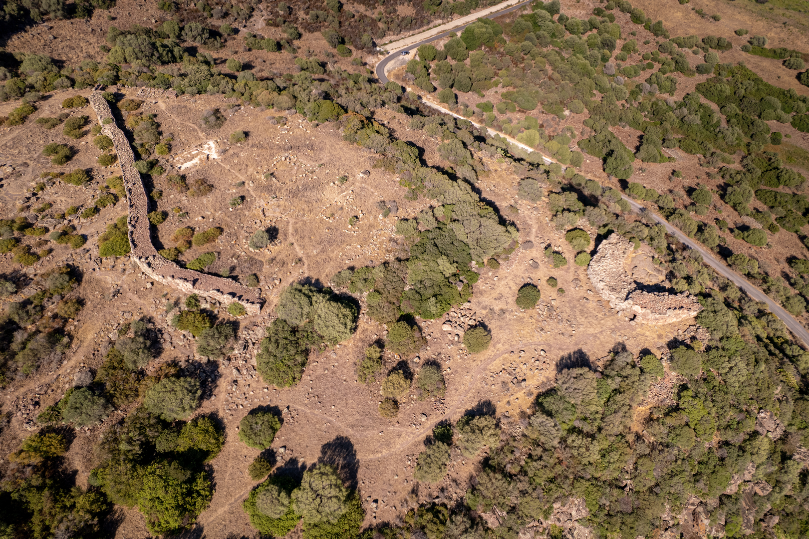
Being part of an evocative landscape, on the eastern edge of the homonymous Trachytic plateau, the extreme southern offshoot of the Padru Salari plateau, the complex is one of the most monumental and significant examples of the final stages of Sardinian Prehistory. It is characterized by a defensive system consisting of a wall, that protects a village of huts, and a tower-fence built on the cliff edge. Outside the wall, a sacred area includes a menhir and a megalithic circle. In addition to the sacred area, in the Mediterranean scrub, clear evidence of other buildings can be seen on the ground.
Ercole Contu first described the wall and the tower-fence in 1962. The excavations conducted by Alberto Moravetti (1979-1981, 2012-2014), resumed between 2012 and -2014 and helped define it as a fortified settlement connected to the Eneolithic facies of Monte Claro (mid-3rd millennium BCE).
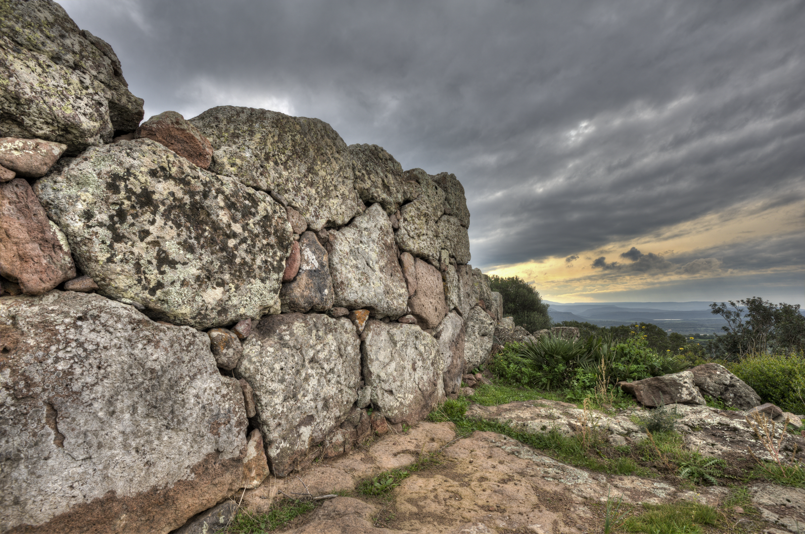
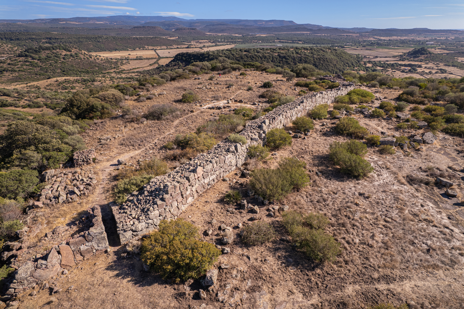
The wall surrounds the “open” portion of the plateau, protected on three sides by a steep cliff, and extends North-to-South on a straight line, except for the first southern stretch, where it folds inwards. It consists of two pebble-filled walls: the outer section consists of blocks, while the inner section of smaller stones arranged in rows. The entrance is located near the N end and includes a rectangular corridor that crosses the wall. At the end of the corridor, on the right of the entrance, a staircase jutting out of the internal wall, probably used to reach the walkway on top of the wall that is no longer available.
Inside the walls, six huts have been identified, with a straight wall profile made with blocks arranged in a single row. The ceiling and the roof, of which no trace remains, were made of perishable material. The quadrangular or trapezoidal huts include remains of paved or cobbled floors and partition walls which divide the indoor space into several rooms. On the floor, often a small quadrangular pit (50-60 cm side) framed by stones and used as a hearth.
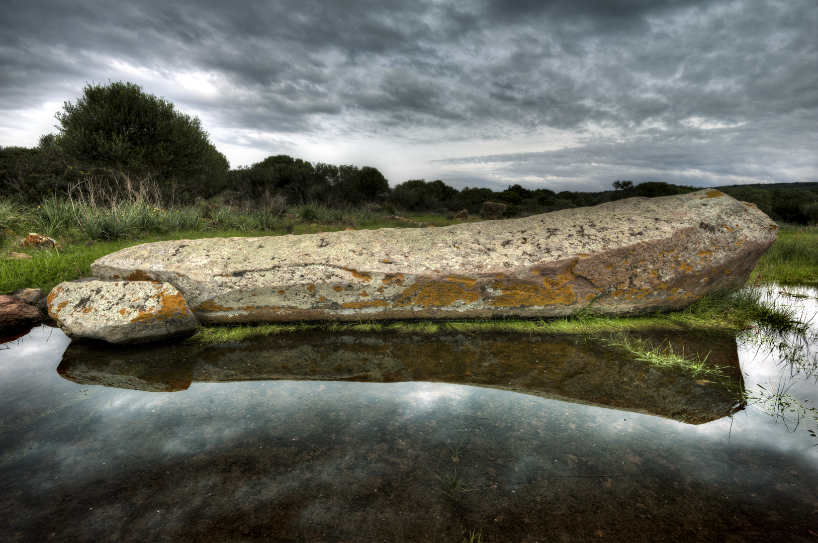
The menhir has a polygonal section and is tapered and slanting at the upper end, lying upside down on the ground. It features a cross rib still to be shaped and a recess near the base, possible to operate it. The menhir was likely to have never been erected: it rests on a perfectly smooth surface where a box engraved on the rock was found, suggesting to be the cavity designed to host it.
The circle, located 13 m from the menhir, has a sub-circular shape and consists of at least thirty large slabs and a large number of small and medium-sized pebbles; a gap of about 4 m opens in the NW section. The tower-fence, located about 60 m SE of the wall, at a lower altitude, on the southern edge of the plateau, features a U-shaped layout that surrounds an area of 191.30 m². The structure ends reach the edge of the plateau; the East side includes no walls as it is naturally protected by the cliff. The external wall is made of large irregularly shaped blocks and arranged in rows, while the internal walls are made of smaller blocks and arranged in horizontal rows. The two partitions are filled with small pebbles. The inner courtyard is accessed through two entrances, one to the North and one to the West, consisting of large lintels on top of two rectangular openings, which lead to slab-covered corridors. Inside the courtyard, on the SW wall, there is a staircase that leads to the top of the monument. In the NW wall, there is a 1.80 m niche raised from the floor. The courtyard floor consists of a smoothed rock outcrop that was leveled by adding pebbles.
The grandeur of the structures and the presence of a major ritual space testify to the great importance of the site for the surrounding region. Other settlements close to the site (Tanca Baranca, Padru Salari) most likely referred to Monte Baranta for both defense and worship activities.
At the current state of knowledge, the presence of a sacred circle that seems to have never been fully used, the large menhir still to be erected, and the unfinished blocks and slabs scattered at the edge of the complex, suggest that the settlement was abandoned by its inhabitants even before the construction phase was completed.
This complex provides significant evidence of the breakdown of the social-economic structure that had characterized the previous Neolithic phase in Sardinia, when, to date, no defensive structures (walls, trenches, embankments, etc.) have been documented. This need for protection is common to other parts of the Mediterranean, in the Aegean Sea and, in particular, in the Iberian Peninsula and in France. The defensive walls found, above all, in central-northern Sardinia, are indicative of instability and a sense of insecurity that sometimes pushed the Monte Claro Eneolithic communities to settle on top of hills and reinforce natural defenses with mighty buildings. This strategic vision of control of the territory anticipates, with different architectural solutions and defensive concepts, the first Nuragic monuments such as the Proto-Nuragic ones (built between the end of the Early Bronze Age and the beginning of the Middle Bronze Age) and then became a common trait of the whole Nuragic Age. The fortified system requires a high place at the ends of plains that overlook valleys, where the settlement area is bordered by the steep hill, and therefore by the defensive walls behind the more exposed, weaker side. Very few pottery and stone materials connected to the Monte Claro culture were found during the excavation surveys conducted by Moravetti in the ritual area. The presence of monoliths seems to testify to the use postulated for this type of monument. During the excavations in the Sa Figu-Ittiri area, conducted by Paolo Melis in 2003, a megalithic circle connected to the Monte Claro culture was found. The most significant analogies with the sacred area of Monte Baranta may be found, in particular, in the Biriai-Oliena settlement, published by Editta Castaldi in 1999: several structures on Monte Claro include a circle of menhirs, two of which are still emplaced in the ground. The sacred area of Monte Baranta could play the same role suggested by Castaldi for the Birai-Oliena area: a sort of astronomical, solar and lunar observatory, to track the passing of time, allowing to record the variation of the seasons for farming.
Monte Baranta is widely present in the European archaeological literature, thus confirming the importance of the monumental complex in the Sardinian and Mediterranean Eneolithic context.
-Monte-Baranta-(39).BhbwbQBH.png)
Bibliography
- Moravetti A. 2000, Il complesso prenuragico di Monte Baranta, Sardegna archeologica, Guide e itinerari 28.
- Doro L. 2023, Il complesso megalitico di Monte Baranta, Olmedo (SS), in G. Tanda, L. Doro, L. Usai, F. Buffoni (eds.), Arte e architettura nella Sardegna preistorica. Le domus de janas (candidatura unesco 2021), Cagliari: 82-89.